Walking the Arran Coast
When I started this blog, I promised that this would be about tech, walking and baking. I've been quite good about blogging tech things, but there hasn't been much of the other two. Time to fix one of those.
I spent last week on a walking holiday, around the coast of Arran, an island in the Firth of Clyde, off the coast of Ayrshire, southwest of Glasgow. It's postition is fortuitous - being on the western coast, it sits in the Gulf Stream, and yet is sheltered from the western Atlantic storms by the Kintyre peninsula. There are palm trees on some parts of the island :). It also lies across the Highland Boundary Fault - the tectonic line which gives Scotland a lot of it's mountains. As such, it's northern part is mountainous, and yet it's southern half is rolling farming land. Not bad for an island 30 miles long. These features have earned Arran the nickname "Scotland in miniature". It's earned this not just for it's geography, but it's produce as well - Arran is known for it's cheese, beer, and whisky.
Arran has had a coastal path for a while - it actually has the domain "www.coastalway.co.uk". We'd heard how nice Arran was from several friends, and we'd already had one holiday abroad this year, so we decided to go walk around it. There are a number of companies that will organise this kind of thing for you (and we have used them in the past) - they book accommodation, make dinner reservations, move your bags from one place to the next, all you have to do is turn up and walk. However, they're quite pricey, so my darling wife spent a heap of time organising the B&Bs herself, and we decided to carry our packs ourselves.
Since this was a one week walk, I'm planning to write up each day separately - I sent myself a email every day with my thoughts on the day, which I'll expand with photos, GPX/KML data so on. For now I'll give the total stat block for the walk, and my thoughts on arrival... stay tuned over the next few days if this interests you.
(Technical note: Sadly, my Garmin GPS can't store a week's data, and I only discovered this when I got home, so I only have accurate GPS data for the last day. The rest has been recreated roughly, from memory. It won't be far wrong though :P)
Friday was a crazy day. I had only got back from a business trip to Europe the day before, with a list of tasks I wanted to accomplish before my holiday. I also had to pack my rucksack for an 8day trip, lock up the house, and be in a taxi by 4.30pm. Somehow, I don't know how, it all got done.

I met up with Mrs ER on the train, and we switched trains in Glasgow Central - it was ridiculously hot and humid there, I felt sticky even without moving. Fortunately the train to Ardrossan harbour was air conditioned, and I could start to relax.
The sea was very calm as we sailed over from Ardrossan to Brodick, and it was easy to grab a few snaps of the approaching island (and thus what we had let ourselves in for). To give you an idea of what we were in for, on the right is a picture of the whole GPX track laid out on a contour map (each day is a different colour).
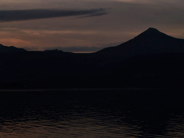
The approach was spectacular in the sunset, with the sun going down behind the right shoulder of the highest peak on Arran, Goatfell. The plan called for walking up that on the last day, on the way down to the ferry home. It looked pretty imposing from out on the ferry (although the light levels didn't allow for the best photos).

Sadly, the chip shop was closed when we got off the ferry (9.30pm - that's island life for you :P). So, we made do with snacks from the local supermarket, and headed to our first B&B for the night (the lovely Rothwell Lodge). It had been a crazy day of work and travel, and sleep was most welcome before the first serious day of walking.
I spent last week on a walking holiday, around the coast of Arran, an island in the Firth of Clyde, off the coast of Ayrshire, southwest of Glasgow. It's postition is fortuitous - being on the western coast, it sits in the Gulf Stream, and yet is sheltered from the western Atlantic storms by the Kintyre peninsula. There are palm trees on some parts of the island :). It also lies across the Highland Boundary Fault - the tectonic line which gives Scotland a lot of it's mountains. As such, it's northern part is mountainous, and yet it's southern half is rolling farming land. Not bad for an island 30 miles long. These features have earned Arran the nickname "Scotland in miniature". It's earned this not just for it's geography, but it's produce as well - Arran is known for it's cheese, beer, and whisky.
Arran has had a coastal path for a while - it actually has the domain "www.coastalway.co.uk". We'd heard how nice Arran was from several friends, and we'd already had one holiday abroad this year, so we decided to go walk around it. There are a number of companies that will organise this kind of thing for you (and we have used them in the past) - they book accommodation, make dinner reservations, move your bags from one place to the next, all you have to do is turn up and walk. However, they're quite pricey, so my darling wife spent a heap of time organising the B&Bs herself, and we decided to carry our packs ourselves.
Since this was a one week walk, I'm planning to write up each day separately - I sent myself a email every day with my thoughts on the day, which I'll expand with photos, GPX/KML data so on. For now I'll give the total stat block for the walk, and my thoughts on arrival... stay tuned over the next few days if this interests you.
(Technical note: Sadly, my Garmin GPS can't store a week's data, and I only discovered this when I got home, so I only have accurate GPS data for the last day. The rest has been recreated roughly, from memory. It won't be far wrong though :P)
Day 0 - Arrival in Brodick
Friday was a crazy day. I had only got back from a business trip to Europe the day before, with a list of tasks I wanted to accomplish before my holiday. I also had to pack my rucksack for an 8day trip, lock up the house, and be in a taxi by 4.30pm. Somehow, I don't know how, it all got done.

I met up with Mrs ER on the train, and we switched trains in Glasgow Central - it was ridiculously hot and humid there, I felt sticky even without moving. Fortunately the train to Ardrossan harbour was air conditioned, and I could start to relax.
The sea was very calm as we sailed over from Ardrossan to Brodick, and it was easy to grab a few snaps of the approaching island (and thus what we had let ourselves in for). To give you an idea of what we were in for, on the right is a picture of the whole GPX track laid out on a contour map (each day is a different colour).
The approach was spectacular in the sunset, with the sun going down behind the right shoulder of the highest peak on Arran, Goatfell. The plan called for walking up that on the last day, on the way down to the ferry home. It looked pretty imposing from out on the ferry (although the light levels didn't allow for the best photos).


Sadly, the chip shop was closed when we got off the ferry (9.30pm - that's island life for you :P). So, we made do with snacks from the local supermarket, and headed to our first B&B for the night (the lovely Rothwell Lodge). It had been a crazy day of work and travel, and sleep was most welcome before the first serious day of walking.